Super typhoons in the Pacific, dust plumes over North America and Russian calderas were among the images captured by European Space Agency and Nasa satellites last month
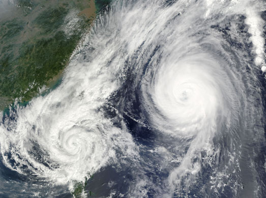
Once a powerful 'super typhoon', Parma crossed over the northern tip of Luzon Island, the Philippines, on 3 October 2009, as a category one typhoon. On 6 October, the storm reversed direction and moved south-east back over Luzon. The cause of this change in direction is shown in this true-colour image. Powerful super typhoon Melor moved close enough to Parma to influence its motion. When two cyclones approach one another, they can interact in a variety of ways. One interaction is the Fujiwara effect, in which the two storms are drawn together and begin to circle each other. In this case, Parma was drawn towards the stronger Melor. This image blends two satellite overpasses to show the proximity of the two storms to one another. The left half of the image, containing tropical storm Parma, was acquired at 10:35am Philippine time. The right half was taken just under two hours later
Photograph: Terra and Aqua/MODIS/NASA
The Guardian
Comments